Laatste video's
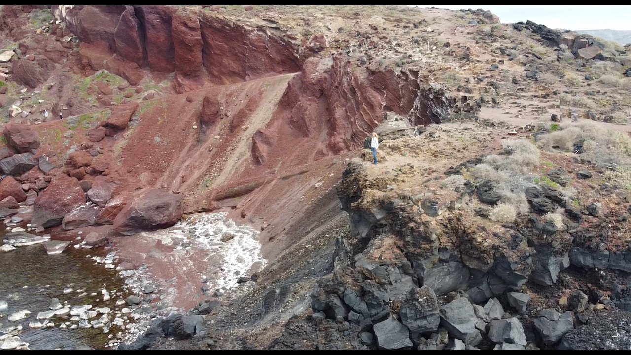
De stranden van Santorini zijn anders dan de klassieke zandstranden. Door de vulkanische oorsprong vind je hier zwart, rood en wit gesteente. Red Beach staat bekend om zijn rode rotswanden. Wij waren hier wel benieuwd naar. En we werden niet teleurgesteld. Spectuculair om de rode kliffen te zien die steil oprijzen uit het donkere zand. Het is geweldig om boven de kliffen te staan en te kijken naar de blauwe zee. Je ziet aan alles dat dit eiland niet ‘zacht’ gevormd is, maar ontstaan is uit vuur, instorting en erosie. Ik ben gaan rondlopen op de kliffen van de muren en we hebben met de drone beelden gemaakt.

Santorini heet officieel Thera of Thira. De naam Santorini zou zijn afgeleid van “Santa Irini”, oftewel Sint-Irene. We startten in de hoofdstad van Santorini, Fira, deze stad ligt hoog op de rand van het eiland, ongeveer 260 meter boven zee. Je vindt hotels die spectaculaire liggingen hebben met mooie uitzichten. Wij boekten dit hotel hierboven en met de drone vlogen we vanuit het hotel de kliffen af, dan zie je hoe mooi het uitzicht is op de Caldera: de ingestorte vulkaankom die nu gevuld is met zeewater.

De ontwikkelingen in het vak van Learning & Development volgen elkaar snel op. Wil je jouw vakkennis actualiseren en verdiepen, volg dan de 4-daagse Masterclass Learning & Development. Deze vindt plaats van 1 t/m 4 sept 2026, onder begeleiding van trainer Laura van den Ouden. Er is plaats voor maximaal 8 deelnemers en de exclusieve locatie is de catamaran van de trainer in Malaga, Zuid-Spanje! Bekijk hier het programma, de kosten, praktische zaken en reviews van eerdere cursisten aan boord van de catamaran: https://experttrainers.nl/masterclass-learning-and-development-malaga/

We love to go to concert, especially artists from the 80's and 90's. And when we found out that Christopher Cross was on tour, we checked out the dates. Christopher Cross is an American singer-songwriter and guitarist from Texas. His all-time classics are Sailing, Ride Like the Wind, and Arthur’s Theme. When we were in the Netherlands in April 2026, he would play in Aalborg, Denmark. Only 8 hours by car ;). So we did and had a great weekend in Denmark, with Christopher Cross' concert being the hightlight!

Mykonos from above during the Golden Hour! We flew our drone over the five windmills and Little Venice — enjoy the view with us!

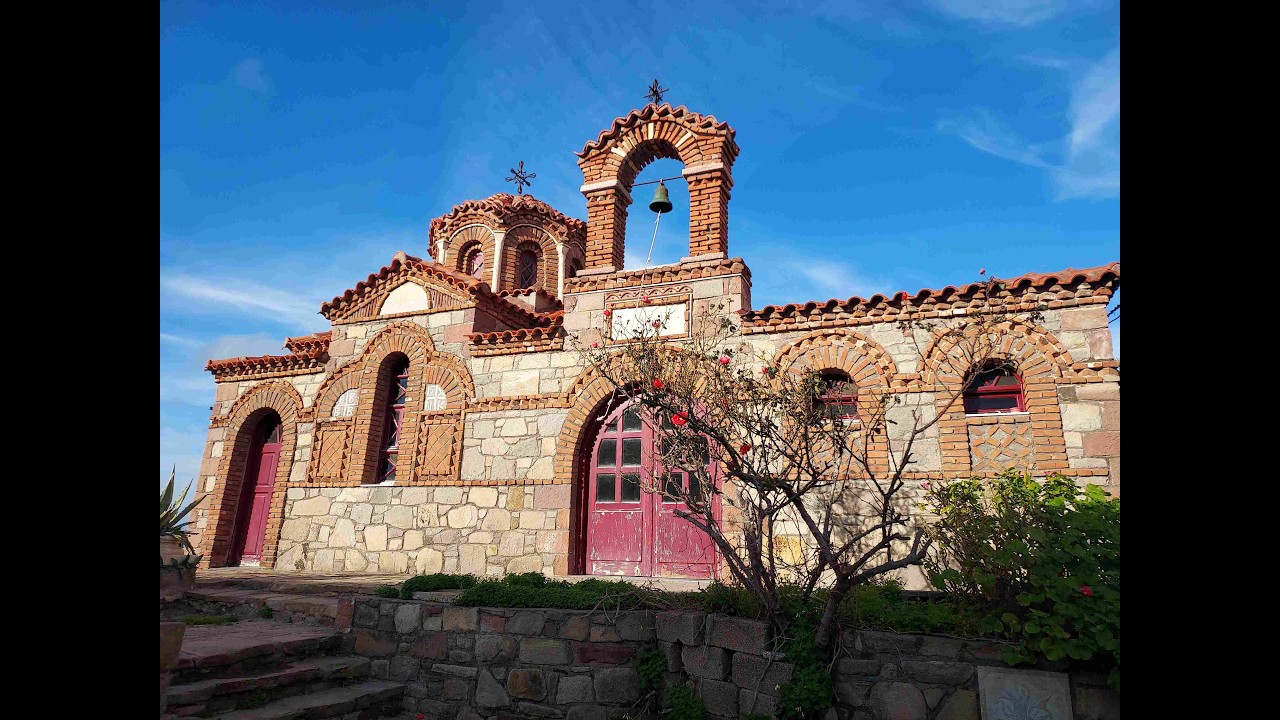
In the harbor of Karlovasi at Samos, when we turned our back to the see, we looked at a high hill with a beautiful church. However, it was quite difficult to get there with our bike and scooter. Luckily—long live the drone—it can take a look almost anywhere 😉 It turned out to be the Church of the Holy Trinity, beautifully positioned on an elevated location above the port. Its prominent hilltop setting offers excellent panoramic views.
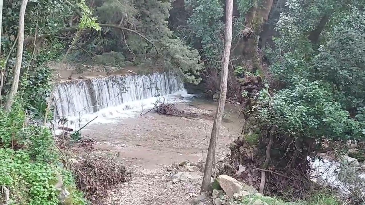
On the northwest coast of Samos, you’ll find the Potami waterfalls. We hopped on our e-bike and e-scooter, and after a 15-minute ride through the mountains from our sailboat, we arrived at this small waterfall. A pleasant path led us there.

Near the town of Karlovasi on Samos, we discovered a small chapel called Agios Nikolaos Chapel. It is often used for weddings because of its picturesque location on a cliff, overlooking the sunset. We parked our bikes and took a look inside the small chapel. We also regularly come across the name “Agios Nikolaos” during our travels through Greece; it refers to Saint Nicholas, the patron saint of sailors.

On our way to Samos from the island of Chios, we were treated halfway through the journey to a group of dolphins swimming alongside the boat. It remains magical—what beautiful animals!

Lesbos is also known for its many waterfalls. They are often dry in summer, but in winter the water flows. After about twenty minutes of scrambling through the forest along a small stream, we reached a waterfall — beautifully hidden, cascading into a natural pool. Our drone captured everything from above.
At the east coast of the island Lesbos, in a small town called Sigri, we walked past a church called Agios Theofanis Theophanes Sugrianis lived in the 16th century and became known as a monk and spiritual leader during a period when the island was under Ottoman rule. His name is still spoken with respect by residents of the region. Inside, the church turned out to be richly decorated, with traditional golden icons and oil lamps that are characteristic of the Greek Orthodox, almost mystical architectural style. Take a look with us inside the church.

We started to walk a steep path into the mountains on the westside of Limnos. We followed a steep trail uphill for about half an hour, winding through the rocky landscape. Along the way, we were rewarded with beautiful views over the Aegean Sea. Suddenly we saw a white cross standing on the highest peak — and there was the cave where the small blue-and-white chapel was hidden. This church has existed since the 13th century, built by monks beneath an enormous rock face. It has no roof; symbolically, the sky itself forms the ceiling. No decoration, no tourist crowds — only stone, air, and meaning. An elderly man was sweeping the open-air chapel with a broom, clearing away the dust the wind had blown inside. He tidied everything, greeted us, and quietly walked away. Then we were alone — that’s how peaceful it is here. I found it one of the most special places I have seen in Greece. We flew with our drone around the cave and the surrounding mountains, while you can see the 13th century open air church in white and blue colors.
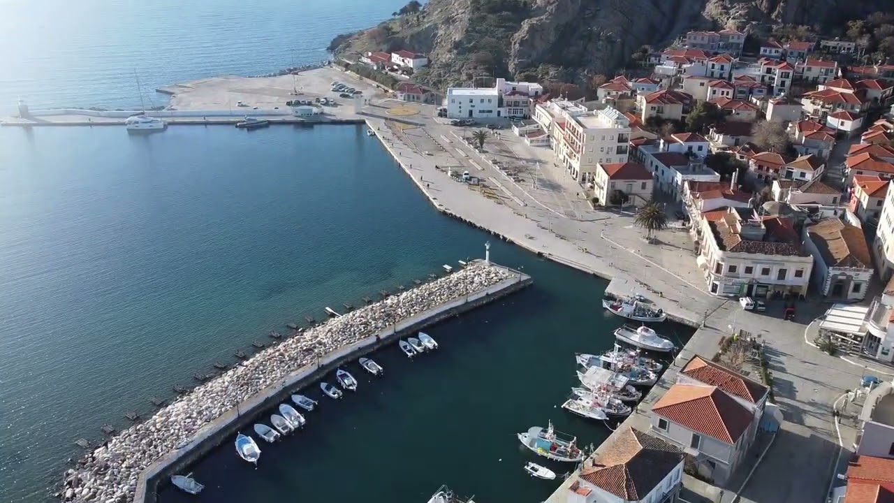
From Turkey, we sailed for 8 hours to the first Greek island we came across: Limnos. We didn’t know the island, but the capital Myrina turned out to have a beautiful marina. The harbor lay beneath a high cliff topped by an impressive Venetian castle. We sent our drone up into the air to take a closer look at this stunning surroundings

We were looking forward to sail on The Bosphorus, the 30 km long strait connecting the Black Sea with the Sea of Marmara, surrounded by the city of Istanbul (15 mln inhabitants!). More than 100,000 vessels pass through each year, so very busy area, we planned our trip with care and checked all the rules about sailing on this water and the strong currents. In this video you will see the Asian side and the European side, filmed from our catamaran, with hightlights like: - the Blue Mosque - Maiden’s Tower - Yalıs: Ottoman wooden waterfront villas - 15 July Martyrs Bridge - Rumeli Hisarı Fortress - Ortaköy Mosque - Galata Tower and Galata Bridge - Hagia Sophia

In the Sea of Marmara, close to Istanbul, you will find The Prince's Islands (Turkish: Prens Adaları, literally “Islands of the Princes”). They are named this way, because they once served as places of exile for princes, members of royal families and other high-ranking figures who had fallen out of favour. During the Byzantine era, unwanted heirs and deposed princes were sent here, far from Constantinople (now Istanbul). Later, under the Ottomans, disgraced relatives of the sultan or other notables were also exiled here — hence the name. Besides the busy islands, there are also small natural islands. We visited one, called Sivriada. We found a lovely small harbour here to stay in. And 4 other boats with Turkish locals arrived later that day, probably from Istanbul, for a day of fishing or barbecuing — the grills appeared in the late afternoon. Very cosy! Look at the amazing colors of the high mountain, which looks like a collapsed vulcano. We flew from the litte harbor with our drone to the mountain and took a look over the sea towards the other Prince's islands.

This is a look back at our sailing year 2025: from Crete through the Cyclades to Athens. Through the Corinth Canal to the Ionian Sea and back again. Along the Sporades islands and the three peninsulas to Chalkidiki, on our way to Turkey, where we celebrated Christmas. Sailing through the Bosphorus in Istanbul and watching the fireworks on New Year’s Eve!

'Do you have a Christmas Tree on board?'. Absolutely, we have a Christmas Catamaran, fully decorated ;). Here is the video of the boat in the harbor, it really stands out!

One of the most iconic spots on Skiathos is Lalaria Beach, on the north coast. This beach is only accessible by boat and is characterized by white pebbles, high cliffs, and a natural rock arch. In calm northern conditions, it is a magical place to anchor or to sail by slowly. The water here is an intense blue and crystal clear—an absolute highlight when seen from the boat.

One of the sails we like to use on Horizon, is the Code Zero. It goes all the way from the front to the end and is very suitably for light winds, because it had 80m2 to cover. We took our drone up in the air, and you can see the main sail + Code Zero sail at work while sailing on the Aegan Sea in Greece!

The small islet of Peristera, which is part of Alonissos (the Sporades island group), has a shipwreck that is partly underwater and partly visible above the surface. We went there, jumped into the crystal-clear water with our snorkeling gear, and saw the ship underwater using our GoPro. Lots of fish and rusted parts. We found it a fascinating sight! And with the drone, we had an even better view of the shipwreck.