Come fare e stile

This video shows how to calculate the number of shackles to be dropped when dropping a ship's anchor. It includes determining the number of shackles that have been dropped by reading the markings on the anchor chain. The calculations are just a reference. There are other methods of calculations and you can use the method you are familiar with.
A ship's anchor is a heavy device typically made of metal that is used to secure a vessel in place by gripping the seabed. Anchors are crucial maritime equipment for ships of all sizes, ranging from small boats to large ocean-going vessels. They are essential for various maritime operations, including anchoring in ports, harbors, and offshore locations, as well as during emergency situations or when conducting maintenance activities.
#maritime
#seafarer
#seaman
#bsmt
#maritimestudents
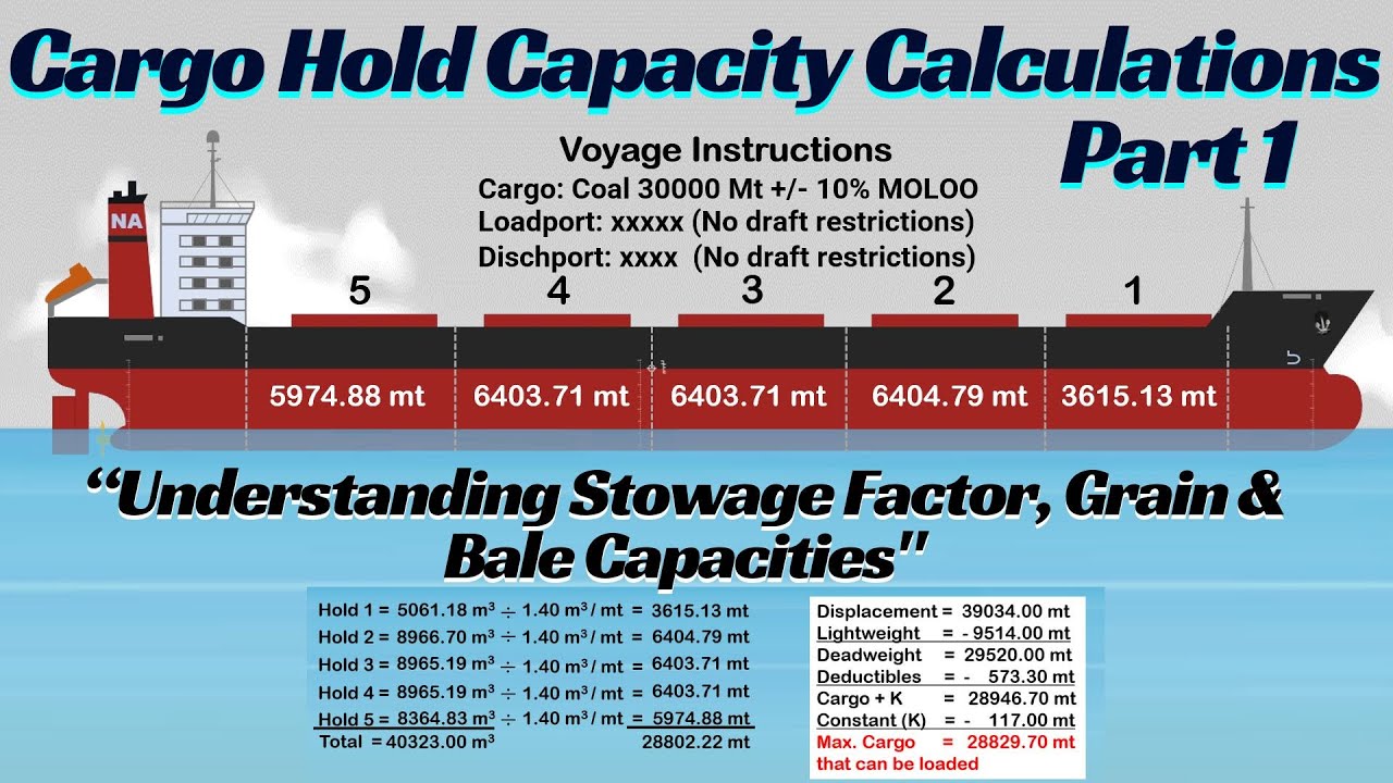
This video shows how to calculate the amount of cargo that can be loaded in each ship's cargo hold. It involves manual calculations.
Stowage factor is a measurement used to indicate how much space a particular type of cargo occupies in a ship's hold. It is usually expressed in terms of cubic feet per metric ton, or cubic meters per metric ton. The stowage factor varies depending on the cargo's density, moisture content, and how tightly it can be packed.
Grain Capacity refers to the total volume of a ship's hold, measured without considering obstructions like frames, or beams. It represents the maximum space available when loading bulk cargo, such as grains or other free-flowing bulk materials, which can fill in around the structural features of the hold.
Grain capacity is generally larger because the cargo fills the entire volume. Bale Capacity measures the usable volume of the hold, taking into account structural obstructions like beams, frames, and other fittings. It is typically used for packaged, or unitized cargo, like bales of cotton, which don’t fill all available gaps.
#stability
#hydrodynamics
#maritime
#seafarer
#seaman
#bsmt
#maritimestudents
#seamanship
#shipstrim
https://youtu.be/lN2uBLmB6Fo
https://youtu.be/aWfxCHdG4LE

https://youtu.be/JKExTQXFSk8
This video shows how to create parallel index lines and set it to radar. It shows how to determine the PI lines including the Not More Than (NLT) and Not Less Than (NMT) PI lines when making a passage plan.
Parallel indexing is a navigation technique used by mariners to maintain a safe distance from a navigational hazard or to ensure that the vessel stays on a desired track. This method involves using radar and electronic navigational charts, or paper charts to create reference lines, known as index lines," parallel to the ship's course, to continuously monitor a vessel’s track, to a pre-determined passage plan.
#radar
#navigation
#passageplanning
#maritime
#seafarer
#seaman
#bsmt
#maritimestudents
#ecdis

https://youtu.be/JKExTQXFSk8
https://youtu.be/P5BKLZ41lN4
This video covers how to determine and mark an Abort Point, Point of No Return, and Emergency anchorage when creating a passage plan.
Abort point is the point along the passage where the vessel can still safely maneuver back, and abandon its planned track for any reason. This point is typically found when approaching or entering a port, or narrow channel, and should be clearly marked in the passage plan.
Point of No Return (PONR) is the point along the passage plan and beyond, in which there is no sufficient sea room to turn back the vessel, such as when navigating in constrained water, when the ship enters a narrow river, or even if there is sufficient sea room, but due to the tide when it is at its low level, the ship is unable to maneuver back, and the vessel has to proceed.
#navigation
#passageplanning
#seamanship
#maritime
#seafarer
#seaman
#bsmt
#maritimestudents

This video is intended for maritime students taking a navigation course about ship's position-fixing technique by radar range and bearing. It shows how to determine range and bearing on the radar and plot manually on the paper chart.
#radar
#navigation
#passageplanning
#maritime
#seafarer
#seaman
#bsmt
#maritimestudents
#ecdis

This video shows how to interpret a displayed vector on the RADAR/ARPA for collision avoidance. It covers the True & Relative vectors when the radar is in Relative motion, Sea Stabilized mode.
True Vector displays the actual movement of a target in relation to a fixed point on Earth. It shows the true course and speed of the target, and it gives a real-world depiction of a vessel’s path over the ground.
Relative Vector represents the movement of a target in relation to the motion of the observing ship or own ship. It shows how the target is moving relative to your own ship’s position and speed. This is useful for collision avoidance, as it indicates how a target’s position changes with respect to your own vessel.
In short, True vector shows a target’s movement over the ground, while Relative vector shows how the target moves relative to your own vessel.
#radar
#colreg
#collisionregulation
#navigation
#passageplanning
#seamanship
#maritime
#seafarer
#seaman
#bsmt
#maritimestudents
https://youtu.be/JQ52DMireIc

How to calculate UKC? https://youtu.be/z2mtGFXi-F0
This video explains CATZOC (Category of Zone of Confidence). It shows how to determine the zone of confidence value to find the actual depth of the water from the stated charted depth in the ENC. It also shows how to activate the layer of accuracy using a JRC ECDIS.
CATZOC stands for Category of Zone of Confidence. It describes the level of confidence or accuracy of hydrographic survey data used in nautical charts. It refers to the quality and accuracy of survey data and the applicable error in the chart datum.
#navigation
#passageplanning
#maritime
#seafarer
#seaman
#bsmt
#maritimestudents
#ecdis

https://youtu.be/kEOWrIFaASs
https://youtu.be/IM4HzhwvLDE
https://youtu.be/spivBg4KCiI
This video contains the effect of a slack tank on a ship's stability. It explains how ships reduce their stability due to partially filled tanks as a result of the virtual loss of Metacentric Height (GM). It includes the calculation of the free surface moment, free surface correction, and applying FSC to determine the fluid GM.
Free surface effect refers to the influence of liquids in partially filled tanks or compartments on the stability of a floating vessel, such as a ship or a boat. When a vessel tilts or rolls, the liquid within these partially filled tanks tends to shift, leading to changes in the vessel's center of gravity and buoyancy.
#stability
#hydrodynamics
#maritime
#seafarer
#seaman
#bsmt
#maritimestudents
#seamanship

https://youtu.be/ANtwr2A6pC0
https://youtu.be/t6tyIeOkyZU
This video shows how to mark clearing bearings in our passage plan. It shows two ways how to use clearing bearings for safe navigation.
Clearing bearing is a navigational technique used to ensure a vessel's safe passage around hazards or dangers, such as shoals, rocks, or other obstructions while sailing. It involves drawing a bearing line on a paper chart or an electronic navigational chart from a prominent point, landmark, or any conspicuous object to the safe side of the danger area.
#navigation
#passageplanning
#seamanship
#maritime
#seafarer
#seaman
#bsmt
#maritimestudents

This video shows the difference between Dead Reckoning (DR) and Estimated Position (EP). It also shows how to determine them and which gives an accurate position.
Dead Reckoning (DR) position is the position of the ship determined solely based on its last known position, course, and speed over a given period, without taking into account external factors such as wind, current, or other navigational influences.
Estimated Position (EP) is the position determined from the DR position but adjusted for known external factors such as wind, and current.
#navigation
#passageplanning
#seamanship
#maritime
#seafarer
#seaman
#bsmt
#maritimestudents
https://youtu.be/HQOd9Y8yOco

This video shows how to calculate a ship's squat and determine how it affects the ship's trim when navigating in open and confined waters. It includes the definition of a ship's squat, under keel clearance or UKC, confined water, shallow water, and block coefficient. It also includes how to use a ship's hydrostatic table to determine the ship's block coefficient.
Ship's squat, also known as "dynamic squat," refers to the phenomenon where a vessel experiences a temporary reduction in draft and an increase in trim when it moves through the water, particularly in shallow or restricted waterways. This reduction in draft occurs due to hydrodynamic forces generated by the vessel's motion.
#seamanship
#maritime
#seafarer
#seaman
#bsmt
#maritimestudents
#shiphandlingsimulator

This video explains the application of a ship's Load Lines when sailing in different zones. The importance of load lines that indicate the maximum depth to which a ship can be safely loaded with cargo in different conditions.
A ship's Load Lines, also known as Plimsoll Lines, are markings found on the hull of a ship indicating the maximum depth to which the vessel may be safely immersed when loaded with cargo. Load Lines are crucial for ensuring the safety and stability of a ship, as they help prevent overloading, which can lead to instability, structural damage, and even sinking.
#maritimelaw
#maritime
#seafarer
#seaman
#bsmt
#maritimestudents
#navigation

This video covers the corrective measures when the ship is in unstable condition, resulting to an angle of loll.
#stability
#hydrodynamics
#maritime
#seafarer
#seaman
#bsmt
#maritimestudents
#seamanship
https://youtu.be/uNfVW_TP8EU
https://youtu.be/xlQpZCogzNM

This video shows the difference between a list and a loll. It explains their causes, characteristics, and corrections.
#stability
#hydrodynamics
#maritime
#seafarer
#seaman
#bsmt
#maritimestudents
#seamanship
https://youtu.be/spivBg4KCiI
https://youtu.be/pSIivbMfUyk

This video provides a step-by-step guide to determining the Gyro Error and the deviation using the Sun’s amplitude, based on the formula: Sin Amp = Sin Dec / Cos Lat. It demonstrates two methods for finding the deviation when variation is applied to the total error.
Additionally, the video corrects an error from Parts 1 and 2 regarding the proper naming of the Sun’s amplitude suffix.
Amplitude refers to the angular distance of a celestial body (such as the Sun or Moon) measured along the horizon—from the East point when the body is rising, or from the West point when it is setting.
#celestialnavigation
#navigation
#maritime
#seafarer
#seaman
#bsmt

This video explains the concept of ship draft, highlighting its critical role in maritime safety and operations. It guides you on how to read draft marks.
Ship's draft is the vertical distance between the lowest point of the ship's hull, known as keel, and the waterline.
#stability
#hydrodynamics
#maritime
#seafarer
#seaman
#bsmt
#maritimestudents
#seamanship
#trim

Speed Through Water (STW) vs. Speed Over Ground (SOG): Why It Matters for Radar Collision Avoidance?
This video shows why Speed Through Water (STW) must be set to ship's radar when used for collision avoidance. It also includes a detailed explanation of the difference between Speed Over Ground (SOG) and Speed Through Water(STW).
Speed Over the Ground (SOG) is the speed at which a vessel moves relative to the Earth's surface. It represents the actual speed the vessel is covering over the ground, taking into account all external factors such as currents, and wind.
Speed Through Water (STW) is the speed at which a vessel moves relative to the water it is traveling through. It is not affected by external factors like currents or wind.
#colreg
#collisionregulation
#navigation
#passageplanning
#seamanship
#maritime
#seafarer
#seaman
#bsmt
#maritimestudents

This video explains the difference between Statical and Dynamical Stability. It focuses on the Righting lever at different angle of heels, Righting moment, and Area under the GZ curve.
Moment of Statical Stability or Righting Moment at any angle of heel is the moment that represents the ability of the ship to return to its initial position when heeled by external forces.
Dynamical stability defined as the work done in inclining the ship, or the energy required to heel a ship to a specific angle. It is quantified by the area under the righting arm known as the GZ curve up to that angle of heel.
#stability
#hydrodynamics
#maritime
#seafarer
#seaman
#bsmt
#maritimestudents
#seamanship
https://youtu.be/dGu3m7-xNgg
https://youtu.be/_XzOScnYwdU

This video shows the difference between Stiff and Tender Ships. What are the causes, characteristics, and corrective actions?
Stiff ship refers to a ship that has a large metacentric height, caused by a KG being too small.
Tender ship refers to a ship with low initial stability due, to a small metacentric height, caused by a KG being too big.
#stability
#hydrodynamics
#maritime
#seafarer
#seaman
#bsmt
#maritimestudents
#seamanship
https://youtu.be/uNfVW_TP8EU

This video covers a detailed explanation of the ship's weight: Lightweight, deadweight, and Displacement.
Lightweight is the weight of the ship itself without any cargo, fuel, ballast, provisions, crew, or passengers. It includes the weight of the hull, machinery, equipment, and anything that is a fixed part of the vessel. It represents the empty weight of the ship.
Deadweight is the total carrying capacity of the ship, which includes cargo, fuel, provisions, fresh water, ballast water, crew, and passengers.
Displacement is the total weight of the water displaced by the ship when it is floating. According to Archimedes' principle, the displacement of a ship is equal to the total weight of the ship and everything on board.
#stability
#hydrodynamics
#maritime
#seafarer
#seaman
#bsmt
#maritimestudents
#seamanship
